Project summary
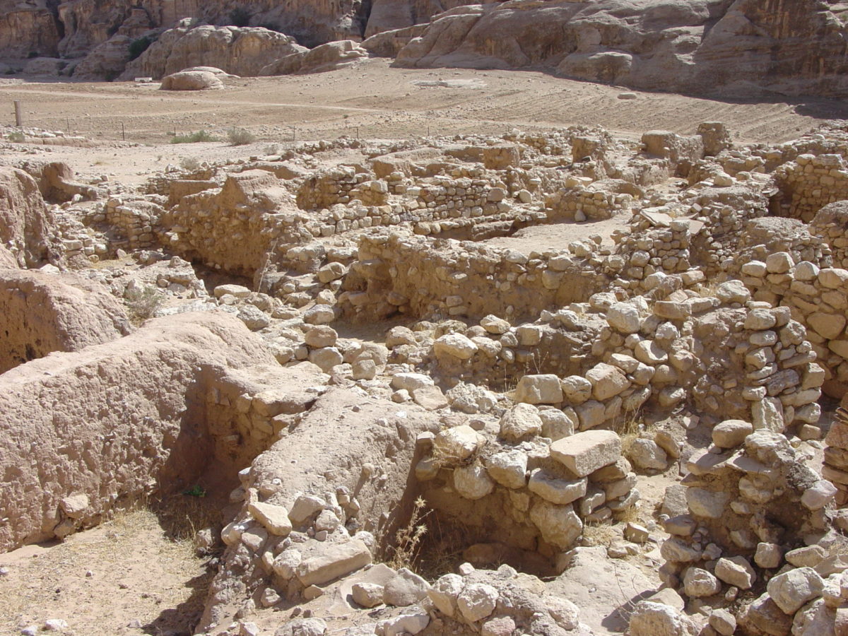
Started in 1958, excavations at Beidha went on for several seasons until 1983, initially under the direction of Peter Parr and then of Diana Kirkbride. The excavations revealed a complex stratigraphy from the Neolithic to the Nabataean period. Several building types were found as well as in-house burials, evidence of productive activities (agriculture, husbandry, workshops) and religious buildings.
Project details
Location: Beidha (Jordan)
Year(s): 1958-1959; 1961-1964; 1965; 1967; 1983
Project director(s): Peter Parr (1958-1959); Diana Kirkbride (from 1958-1959 onwards)
Project team:
1958-1959
- Philip Hammond (assistant director),
- Crystal Bennett,
- Père H.M. Couasnon,
- Sami Rashid (DoAJ Representative 1958),
- Crystal Bennett,
- J. Jeffers,
- Mr and Mrs Gilbert Kennedy,
- William Lancaster,
- Dorothy Marshall,
- Madeline Parr,
- T.J. Thornton,
- G.R.H. Wright,
- Abed Shorafa, (DoAJ Representative 1959).
1961-1964
- Alexander Hamilton (architect),
- Brian Johnson (architect),
- Oliver Unwin (architect),
- Ian Todd (site supervisor),
- Sayed Mohammad Murshed (DoAJ Representative, site supervisor),
- Kay Wright (site supervisor),
- Riet Versteeg (site supervisor 1963),
- Sayed Ahmad Shestawi (DoAJ Representative, site supervisor),
- Eileen Morton (site supervisor 1964),
- Hans Helbaek (palaeoethnobotanist),
- Dexter Perkins Junior (zoologist),
- R.L. Raikes (hydrologist).
1965
- Brian Johnson (architect),
- Ian Todd (site supervisor),
- Peder Mortensen (site supervisor)
- Timothy Strickland (site supervisor)
- Sayid Faiz Tarawni (DoAJ Representative, site supervisor),
- Frances James (site supervisor),
- Marylyn Thomas (site supervisor).
1967
- Brian Johnson (architect),
- Rev. A.J. Arkell (site supervisor),
- Rev. Father Francis Hours (site supervisor)
- Iain Davidson (site supervisor)
- es-Sayyid ‘Abd el Jalil ‘Amr (DoAJ Representative, site supervisor),
- Lesley Ketteringham (draughtswoman),
- Cecil Western (botanist)
- Nancy Lord (photographer)
- Mrs A.J. Arkell (registration)
- Mrs J.H. Grimes (registration)
1983
- Brian Byrd (site supervisor, back up surveyor, draughtsman, photographer),
- Don Bunyan (photographer, site supervisor),
- Madame Adelaide Fenaille-Kamir (site supervisor, flint sorter),
- Howard Hecker (zoologist, site supervisor),
- Brian Johnson (architect),
- Bob Erskine (surveyor),
- Niazi Shab’an (DoAJ Representative, site supervisor).
Lead institutions and funding:
1961-1964
- BSAJ (grant from British Academy),
- Ashmolean Museum,
- Museum of Archaeology and Ethnology Cambridge,
- American Philosophical Society,
- Palestine Exploration Fund (1961),
- Bollingen Foundation of New York,
- Wenner-Gren Foundation for Anthropological Research.
1965
- BSAJ,
- British Academy,
- Bollingen Foundation of New York,
- Wenner-Gren Foundation for Anthropological Research.
1967
- BSAJ,
- British Academy,
- Bollingen Foundation of New York,
- Wenner-Gren Foundation for Anthropological Research
- Two private donors.
1983
- British Institute at Amman for Archaeology and History,
- Department of Antiquities of Jordan,
- Yarmouk University.
Partners:
- British Museum,
- British School of Archaeology in Jerusalem,
- Ashmolean Museum,
- Society of Antiquaries of London,
- Gerald Averay Wainwright Foundation,
- University of Oxford,
- University Museum Manchester.
Project description
Summary: Seasons 1958-1959
The first season was carried out during autumn 1958, the second in 1959. Chief aims of these first two seasons were to excavate across the site horizontally (with some deeper digging in areas) to trace the plan of a Neolithic village, the architecture of individual dwellings, and obtain evidence for the practice of agriculture and domestication of animals. Additionally, it was hoped to make connection with the Pre Pottery Neolithic B phase of Jericho, to find the Natufian level, and to see if there was a break or transition between the two periods. Due to terracing of the site during the Nabataean period, excavations on the top terrace required deeper excavation to reach the same levels as on the lower terrace.
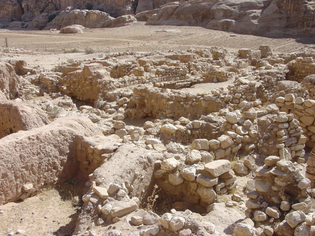
The main area of excavation on the highest part of the tell revealed a complex of rooms, opening off long corridors and constructed of dry stone built walls. The most complete unit had an entrance passageway approached by two descending stone steps then six rooms arranged in three pairs. Further buildings of this type, which had been constructed earlier, were excavated in 1959. The contents of these rooms varied, from querns, grinders, rubbers and pestles to ibex horn-cores. During 1959 one series of rooms contained animal bones, articulated joints and heads, with stone tools and implements such as choppers, grinders, hammer stones, slabs, suggesting animal butchery and processing was undertaken. More ibex horn-core remains were recovered, as well as pestles, mortars, loom weights, bone and flint tools.
Fragments of polished plaster coloured red with haematite were recovered from the debris that filled some rooms, possibly from plastered ceilings. Other buildings were found to have had plastered floors, like those found at Jericho, as well as human burials. These were infant, youth and adult burials, with the youth and adult skeletons missing their heads. One youth burial contained the skull, which was laid beneath the body.
Excavations below the second Nabataean terrace wall found a partially subterranean building, architecturally differently to the corridor structures. A deep sounding made in 1958, through three meters of layers and two metres of soft sand reached the Natufian level of occupation. Another soundings made to obtain samples of the flint industry on site revealed a circular hearth, outlined with stone slabs, with remains of animal bones, horn-cores and flint tools.
To sum up, during the first two seasons two different building types were found. There was no evidence of defensive structures or fortifications. The buildings had plastered floors of two types, some burnished like at Jericho, others resembling modern cement, while in a later period the floors were of beaten earth but the ceilings may have been covered in coloured plaster. Burials of headless skeletons like at Jericho, were found within some of the buildings.
The large number of animal remains recovered provides evidence of the fauna of the area; ground stone tools indicate grain was harvested and processed, and so agriculture was practised. Marine shells used as beads, mother of pearl pendants and oyster shells were recovered as well as lumps of haematite and copper ore.
Summary : Seasons 1961-1964
Remains of four superimposed villages were discerned, each with its own series of rebuilding. The area of excavation cleared of top sand and now at Level II across the site, measured roughly 60 x 35 metres. The entire complex of Nabataean or Roman terrace walls and the few remnants of the first village were removed.
Level I: Includes a single house, wall fragments behind the upper terrace. A few foundations and fragments on the second terrace remained of this period.
Level II: Levels II and III architecture and general layout are almost the same, with Level II the most complete. Comprised of a large free standing single roofed house and a series of corridor buildings along the west and south sides and refuse dumps outside the north and east walls. Further corridor buildings, away from the large house, were built at different orientations. All the buildings were subterranean and entered by three stone steps, some had plastered floors.
The finds from these buildings strongly points to them having been used as workshops rather than dwellings and that they likely had an upper storey, or a roof, where various activities could have taken place.
Evidence from these buildings and other areas on site suggest ceilings were constructed using plaster and reeds and were painted red.
Level III: Little evidence of the Level III large house remained (remnant of plaster floor and hearth with a sill). The corridor buildings of this period lay directly below those of Level II, some of which had been cut into by the Level II structures.
Level IV: Apart from the large house which had been burnt, most evidence for this period is from the eastern side of the tell, where the buildings display a different plan to those of Levels II and III. These houses were sub-rectangular in plan with curving walls, single roomed and subterranean, with plastered floors, walls and hearths with sills and separated from each other by open spaces or yards. The construction method used also differed as these structures used flat mudstone slabs with a sandy mortar in between. The later structures were built of roughly square boulders with smaller stones packing out the gaps.
Level V: A sounding on the upper part of the tell below the Level II large house revealed remains of two round houses, with fragments also found elsewhere on site.
Level VI: Continuation of the sounding between the round houses of Level V revealed a small hexagonal building, built differently to the other round houses. Instead of one continuous wall, this was made up of six short straight walls with angular joins. Remains of similar houses were found elsewhere on site, some with plastered floors and central post holes.
Summary: Season 1965
Summary of results from previous seasons: Level I is almost entirely eroded, but from scant remains it displays houses similar to those of Level IV. Levels II and III have a series of rectangular buildings containing six small rooms, three on each side of a central corridor. These seem to be workshops and may have had upper stories for living quarters. The buildings were laid out round large single-roomed house and series of courtyards. These corridor buildings represent an architectural tradition different to that seen in Levels VI-IV.
The 1965 season concerned exclusively with pre-Level III periods.
Level VI: Contains the earliest Neolithic houses yet found on site. Arranged in separate clusters, the houses are roughly circular in plan with rooms in the clusters round an inner skeleton of posts and beams. Some walls and floors were plastered, evidence suggests that ceilings also were plastered below the beams while above the beams brush or reeds were laid at right angles, supporting thick clay roof. Each separate cluster of houses was surrounded by a wide wall, outside wall courtyard with chalky plaster floor, like that found in Level VII. Courtyards contained hearth and postholes suggesting use of awnings. Storerooms grouped between main living rooms and interior face of surrounding wall.
Level V: Displays advances in architectural practice; the houses found to date have a single room and are free standing. One example found with nineteen postholes set in wall slots, another posthole set off centre, floor paved with small, flat, irregular stone slabs with traces of worn lime plaster near central posthole. Burnt roof found intact on floor, constructed of beams, brush, ceiling plaster and roofing clay. Circular, curvilinear and roughly rectangular examples without postholes also excavated.
Level IV: Displays continuity of building techniques: houses are single roomed with plastered walls and floors, display a variety of sizes possibly reflecting social or economic differences. Hearths moved from exterior to interior, some houses built directly on those from Level V.
New burials were found, reaching a total of forty three. These are single burials, mostly infants and children. The majority of burials was found in ruined buildings. The infant burials were intact while some adult and adolescent burials were found headless. Finds included stone implements such as grinders, polishers, axes/hoes, querns, whetstone, mortars, pestles, rubbers, granite tough, figurines of baked clay, remains of wooden bowl and wooden box, bitumen covered basket, ochres, clay and malachite, bone tools, flint arrowheads and points.
Evidence of Natufian occupation, lithics, animal bones, building remains excavated in various areas on site. The Neolithic settlement of Beidha was occupied for about 500 years, from c. 7000 to 6500 B.C., with six main levels of permanent occupation.
Summary: Season 1967
In 1967, the excavation season ran April to May. The main aim was to investigate pre village Neolithic levels and try to reach level of Epipaleolithic hut floor found running under the wall of House XVIII, Level VI.
Three main areas were investigated:
1. Sounding made in open courtyard levels of Squares G, H, J4, to investigate pre Neolithic levels and clear way for deeper sounding into Lower Natufian levels, divided from Neolithic by two metres of sterile wind blown sand.
The courtyard contained large hearths, contemporary with Levels VI-V. The middle levels, connected with Levels V and VI, contained two separate masses of thick clay, possibly rough huts or shelters. The lower levels, which antedate the earliest stone buildings of Level VI, contained series of large, flat sandy floors with postholes with stone packing.
One end of the sounding dug down through two metres of soft, sterile sand to the Lower Natufian horizon, containing typical flint assemblage, bones and shells.
At the eastern end, were remains of hearths and a large pit cut down from Level III. Soft sand underlying village level not sterile, filled with various remains.
2. Sounding on side of Level VI House XVIII to investigate Epipaleolithic level. Unable to excavate further this level. Trench extended on eastern side of tell, uncovered a set of Neolithic stone steps connected each side with stone wall. Wall excavated on western edge, found to encircle Level VI and subsequent villages, terrace retaining wall and not defensive. Wall traced on northern side of tell, provided protection to village and its buildings from wind.
3. Sounding about 40 metres east of village to examine roughly sub-triangular shallow white sandstone basin, extended towards village to link both areas. Buildings of Neolithic period were found to north, west and east of the basin. The three fully excavated structures were curvilinear, roundish or roughly oval walls, with floors and parts of semi-subterranean walls. Stratified with evidence for different levels of building, enlargement, alteration and cutting into each other.
The western most structure (T2) was roughly round, with a raised doorway on the east side, a large flagstone floor (unlike anywhere else on site), clean floor, fill of hard clay mixed with boulders, containing some flint debitage and burnt bone remains from a meal.
The central structure (T1) is the largest and most elaborate. Roughly oval, at same level as the basin, has a floor made up of small angular pieces of purposely broken stones, carefully laid. It contained a number of thin stone slabs with single standing stone set on edge in centre of the structure. There is evidence of enlargement of the structure at its western end. Clean floor (scatter of shell beads) and fill similar to that from the western structure (T2). Various levels and remains excavated within structure, including deposit resembling iron or rust.
The third building (T3) was roughly oval with floor of fine, clean gravel, containing evidence of a superstructure or roof. Burnt, clayey deposit containing powdered and carbonised remains from beams, below which foundation remains for central stone slab. Below gravel floor deposit resembling rust like that from T1, not found elsewhere on site, possibly deliberately laid down.
The structures may relate to cultic practices on site.
Summary: Season 1983
The new area found at the end of the 1967 season of excavations at Beidha consisted of three curvilinear, semi-subterranean structures built in the same style as the earliest houses, but without wall slots. Each had carefully laid stone floors, the largest house a standing stone in the centre, aligned to the cardinal points, below the floor a circular enclosure outlined with small stone slabs. The area was interpreted as a sanctuary and, before the end of the excavations, a trench was open to join this area to the village.
During the 1983 season, four main activities were carried out:
1. Soundings around the sanctuary area: Remains of Neolithic huts, hearths and camping floors were found, earlier than both the village and sanctuary. The structure with the standing stone was built over this level, the paved floors cut down through the huts. The Neolithic huts had clay walls, floors of stamped clay or fine gravel, hearths outlined with stone. The character of remains is different to the pre-village levels found in the main village, less substantial, possibly a camping area, in use for a season or two, with no accumulation of occupational debris.
2. Trench joining sanctuary area to the village: Continued work on wall found in 1967, running diagonally from the village and turning south to cut off sanctuary area from the village. Sections of wall were robbed out anciently to create the terraces of Nabataean period. The area was greatly disturbed and there was little to be gained by continuing excavation.
3. Soundings and excavations in the village: A series of small soundings were made below floors or in open spaces outside the earliest buildings. The soundings clarified the relationship of levels across the site. In addition, two houses with west walls visible were fully excavated. The houses excavated are of Level IV type. One cut into by third Nabataean terrace wall, had fine plastered floor, two platforms of stone boulders, a quern and large stone bowl set into floor. The second house was later, with a small round hearth, rough stone platform, a quern and various ground stone implements. Remains of the floor of a third house was found, with red painted plaster, a quern and flat flagstone table, the rest of which had been destroyed by the Nabataean terrace wall.
4. Investigation of the Natufian levels: In previous seasons, evidence of Natufian levels was found along talus of the tell weathered by Seyl ‘Aqlat and from soundings inside the village, however the new soundings made in the trench joining the village to the sanctuary area showed no evidence of Natufian levels.
Project bibliography
Byrd, B.F., 2005. Early Village Life at Beidha, Jordan: Neolithic Spatial Organization and Vernacular Architecture. The Excavations of Mrs. Diana Kirkbride-Helbaek. Oxford: Oxford University Press/CBRL.
Helbaek, H. 1966. Appendix A: Pre-Pottery Neolithic Farming at Beidha a preliminary report. Palestine Exploration Quarterly (PEQ) 98, 61-66.
Kirkbride, D. 1962. Excavation of the Pre – Pottery Neolithic Village at Seyl Aqlat, Beidha. Annual of the Department of Antiquities of Jordan (ADAJ) 6-7, 7-12.
Kirkbride, D. 1966. Five Seasons at the Pre-Pottery Neolithic Village of Beidha in Jordan. Palestine Exploration Quarterly (PEQ) 98, 8-72.
Kirkbride, D. 1967. Beidha 1965: An Interim Report. Palestine Exploration Quarterly (PEQ) 99, 5-13.
Kirkbride, D. 1968. Beidha 1967: An Interim Report. Palestine Exploration Quarterly (PEQ) 100, 90-96.
Kirkbride, D., 1984. Beidha 1983: An Interim Report, Annual of the Department of Antiquities of Jordan (ADAJ) 28, 9–12.
Kirkbride, D., 1985. The Environment of the Petra Region during the Pre-Pottery Neolithic, in Studies in the History and Archaeology of Jordan, ed. A. Hadidi. Amman: Department of Antiquities, 117–24.
Perkins Jr, D. 1966. Appendix B: The Fauna from Madamagh and Beidha a preliminary report. Palestine Exploration Quarterly (PEQ) 98, 66-67.
Raikes, R.L. 1966. Appendix C: Beidha Prehistoric Climate and Water Supply a preliminary report. Palestine Exploration Quarterly (PEQ) 98, 68-72.
Project media gallery
Published:12 April 2021


