Project summary
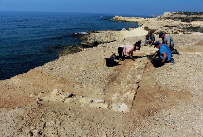
The project investigates settlement and exploitation of Akrotiri, as geomorphological processes turned Hellenistic island into Byzantine peninsula. A harbour and villages are explored, in the context of landscape, region and maritime networks. The project is a unique University of Leicester collaboration with Operation Nightingale, helping military injured recover through archaeology.
Project details
Location: Cyprus
Year(s): 2016
Project director(s): Simon T. James
Lead institutions and funding:
- CBRL
Project description
The project investigates Classical to Byzantine life and settlement during massive, centuries-long geomorphological changes and sudden shocks, both seismic and political/military, in a near-pristine archaeological landscape at the southernmost tip of Cyprus, within and around RAF Akrotiri airbase.
Around 2000 years ago formation of a huge tombolo beach changed Akrotiri from an island to a peninsula, radically transforming southern coastal Cyprus. This diverted marine currents and trade routes, while opening up new land to settlement from the main island. The nascent peninsula extended the territory sustaining the major city of Kourion, and apparently now formed its gateway to the wider Mediterranean.
Limited past work suggests that settlement and exploitation of Akrotiri expanded massively, from quarrying and a few isolated Hellenistic and early Roman structures, to multiple late Roman villages, while a seaport developed at Dreamer’s Bay. But what was the exact chronology of tombolo formation? How did this process relate to intensifying human settlement, and the region’s maritime interactions with Egypt, the Levant, and beyond? How was life on Akrotiri affected by multiple seismic events which struck Cyprus in the 4th c. AD, especially the huge earthquake and tsunami which devastated the eastern Mediterranean in AD365? Were the villages and seaport victims of these events, or responses to their impact, which saw destruction of the classical city of Kourion, and the raising of a Christian Byzantine town on its ruins? What were the maritime connections of the Dreamer’s Bay port?
It has been argued (Procopiou 2014) that Akrotiri was also caught up in another, resonant ancient tragedy: flight to Cyprus of Christian clergy bearing holy relics, and thousands of the faithful from Jerusalem and Egypt in face of Persian invasion in the 610s, leading to construction of a major but short-lived martyrium complex, currently being dug. Did Christian refugees really turn Akrotiri it into a semi-permanent refugee camp until the tide of war allowed them to return home? Was this why a densely settled landscape was then apparently deserted? Or was it, as conventionally believed, due to subsequent Muslim sea raiding, or some other dynamic?
The planned programme addresses a priority in Cypriot archaeological research: better investigating Greco-Roman and Byzantine life by rectifying past over-concentration on urban centres, expanding attention to the countryside with which cities were in symbiosis. Another even wider international research theme is understanding
ancient cities’ long-distance networks, which brought new people, goods and ideas. The Akrotiri peninsula is ideally suited to address such an agenda. Its landscape survives exceptionally well because it lies within a UK military base which, paradoxically, protects both natural and archaeological heritage from commercial development.
Project bibliography
James, Simon T.. 2017. Excavations of Roman/Early Byzantine Structures at Dreamers Bay, Akrotiri. Bulletin of the Council for British Research in the Levant 2016-17, p 44-47.
Published:01 February 2022


