Project summary
The project explores how Cyprus responded to climate change and how these changes affected the development of the local societies in the past, in particular during the early and late Bronze Age, when climate variability is considered to have been one of the concurring causes that led to societal collapse on the island.
Project details
Location: Cyprus
Year(s): 2018
Project director(s): Matthew J. Pound (Northumbria University), Emma P. Hocking (Northumbria University), Calian J. Hazell (Northumbria University)
Lead institutions and funding:
- CBRL
Project feature article (featured in CBRL’s Bulletin 2018)
Background, aims and methodology
Understanding past climate and environmental change is crucial to predicting the potential wider implications of anthropogenic climate change. Arid and semi-arid regions are particularly vulnerable due to the fine balance between water availability and societal demands. Should future anthropogenic climate change be kept to the Paris 2015 Agreement, and not surpass 2°C in the next century, then the Mediterranean Basin’s climate and environment will change in a way not seen for thousands of years. Cyprus, as a semiarid island, has been identified as an area where biodiversity and agriculture are facing a complex threat from future variability in temperature and precipitation. This may also be a contributing factor to societal collapse on Cyprus in the early and late Bronze Age. However, current understanding of how the island of Cyprus responded to this past climatic variability is based on low resolution records – greater than 100 years between samples. Our aim is to generate new high-resolution multi-proxy palaeoenvironmental datasets to set Bronze Age Cypriot societies into a wider context of terrestrial and marine environmental change.
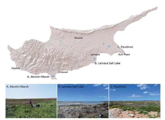
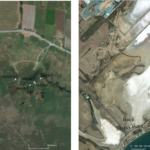
In our first field season we evaluated sedimentary archives along the south coast of Cyprus and collected nine cores spread over three locations.
Results
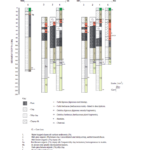
Five cores were taken from the Akrotiri Marsh to a maximum depth of 225 cm and we identified 10 sedimentary units in these cores, with different units reflecting changing environmental conditions through time.
We generally saw a transition from creamy white clays (units 8-9), to brown clays (unit 7), to organic-rich clays and peat (units 5-6), with the most recently deposited sediments being red or brown clays (units 1-4). Three cores were also taken from Larnarca Salt Lake and sub-sampled in the field for microfossil analysis (Figure 1, 2; Table 1). We identified four sedimentary units in the three cores from the Larnaca Salt Lake all of which were clays, except the topmost 2cm that were more sandy. Microfossil analyses (diatoms and pollen) are currently underway, and six samples (wood and plant macrofossils) have been taken for high-precision radiocarbon dating.
To raise awareness of our research we were able to meet with key local stakeholders: the Geological Survey Department of Cyprus and the Akrotiri Environmental Education and Information Centre. We signed a Memorandum of Understanding with the former, which will greatly improve future coordination. Once our microfossil analysis is complete and the cores have a chronology, we intend to work with the latter to produce appropriate outreach materials to support their aim to promote the important cultural and environmental heritage of the Akrotiri Peninsula. We were also able to meet with archaeologists from the Ancient Akrotiri Peninsula project whom we hope to collaborate with further as this research develops.
Discussion
Our initial interpretations of the Akrotiri Marsh cores are based purely on sedimentological evidence and may change once the microfossil analysis is complete and a chronology is established. The Akrotiri Marsh sediments suggest a change in the depositional environment from the basal white sediments (units 8-10) that may represent weathered chalk soils with limited vegetation present. By unit 7, a more vegetated soil had formed and the mottling may well represent fluctuations in soil moisture content. Units 6 and 5 are both organic rich and were formed in a wetland environment.
Subsequently, we interpret units 2-4 as representing a drying of the environment and possible terrestrialisation of the wetland. All sediments from the Larnaca Salt Lake suggest deposition in a lagoonal salt lake environment. The unusually dark layer at the top of the cores is caused by modern volatile organic sulphur compounds.
Future work
We are now processing a sample every 2cm along the sediment cores to produce our high-resolution (less than 30 years between each sample) palaeoenvironmental record of Cyprus, which will be supported by radiocarbon dating. Our immediate objective for the future is to retrieve a longer core from Paralimni. At this location, the compact nature of the sediment meant it could not be effectively cored manually and so we intend to use a mechanical corer. Once we have our high-resolution palaeoenvironmental record we intend to integrate it with archaeological evidence for civilisation changes and/or collapse in Bronze Age Cyprus.
Acknowledgements
We are grateful to Chris Hadjigeorgiou of the Geological Survey Department, Cyprus, Thomas Hadjikyriakou of the Akrotiri Environmental Education and Information Centre, the Ministry of Defence and Defence Infrastructure Organisation for enabling us to undertake fieldwork and take samples. Miltiadis Polidorou is thanked for his kind support on Cyprus in locating coring sites.
Project bibliography
Pound, Matthew J., Hocking, Emma P., Hazell, Calian J. 2020. Providing the palaeoenvironmental context to the boom and bust of prehistorical Cypriot societies: report of the first field season in March 2018. Bulletin of the Council for British Research in the Levant 2018-2019, pp 31-32.
Project gallery
Published:22 November 2021