


By Dr John B. Winterburn, CBRL Travel Grant recipient and Research Associate at University of Oxford.
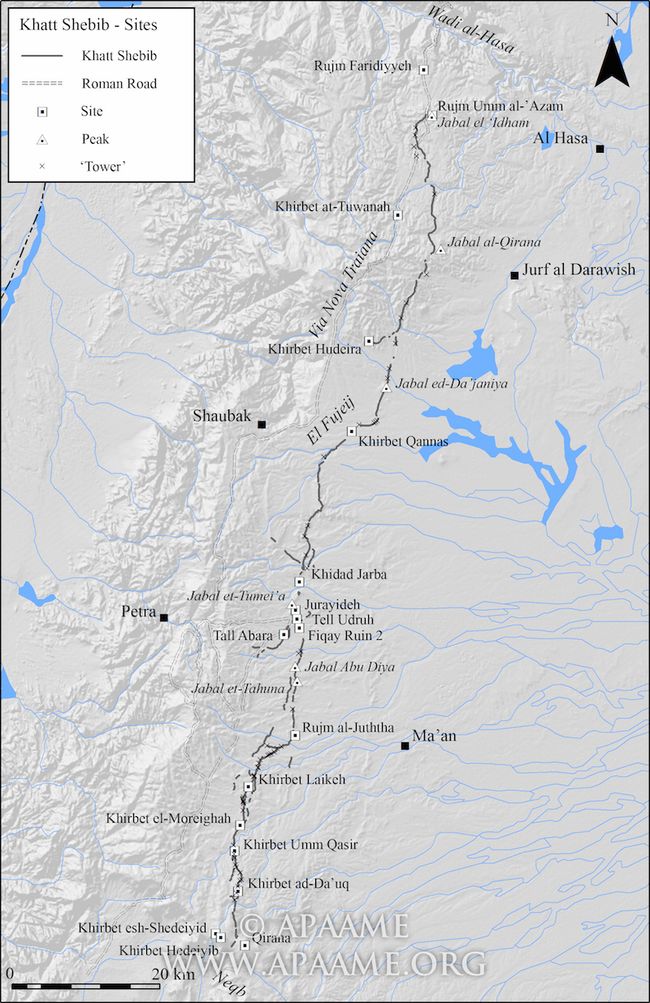
The Khatt Shebib is a mysterious linear stone feature that runs for 150 kilometres across southern Jordan. Sir Alec Kirkbride, the British Ambassador to Transjordan, first recorded the feature in 1948. In what was an early example of aerial archaeology in Jordan he observed a long ‘wall’ while flying over the Ma’an district in the south of the country. A local inhabitant told him it was called Khatt Shebib (Shebib’s Wall). Sir Alec undertook some fieldwork riding a horse along the feature and, later had the opportunity to fly over the line further to the north and was able to produce the first map, published in his 1948 paper, Shebib’s Wall in Transjordan.
The date for the construction of the Khatt Shebib is uncertain. Initially thought to be medieval (tenth-century CE) in origin, the balance of opinion, based on its relationship with other structures, is that it is far older. Recent, limited, scientific dating work using optical techniques supports a possible prehistoric date for its origins. It is an exciting development as the first absolute dating of the feature, and it may lead to a better understanding of its function. However, further and more extensive work is needed.
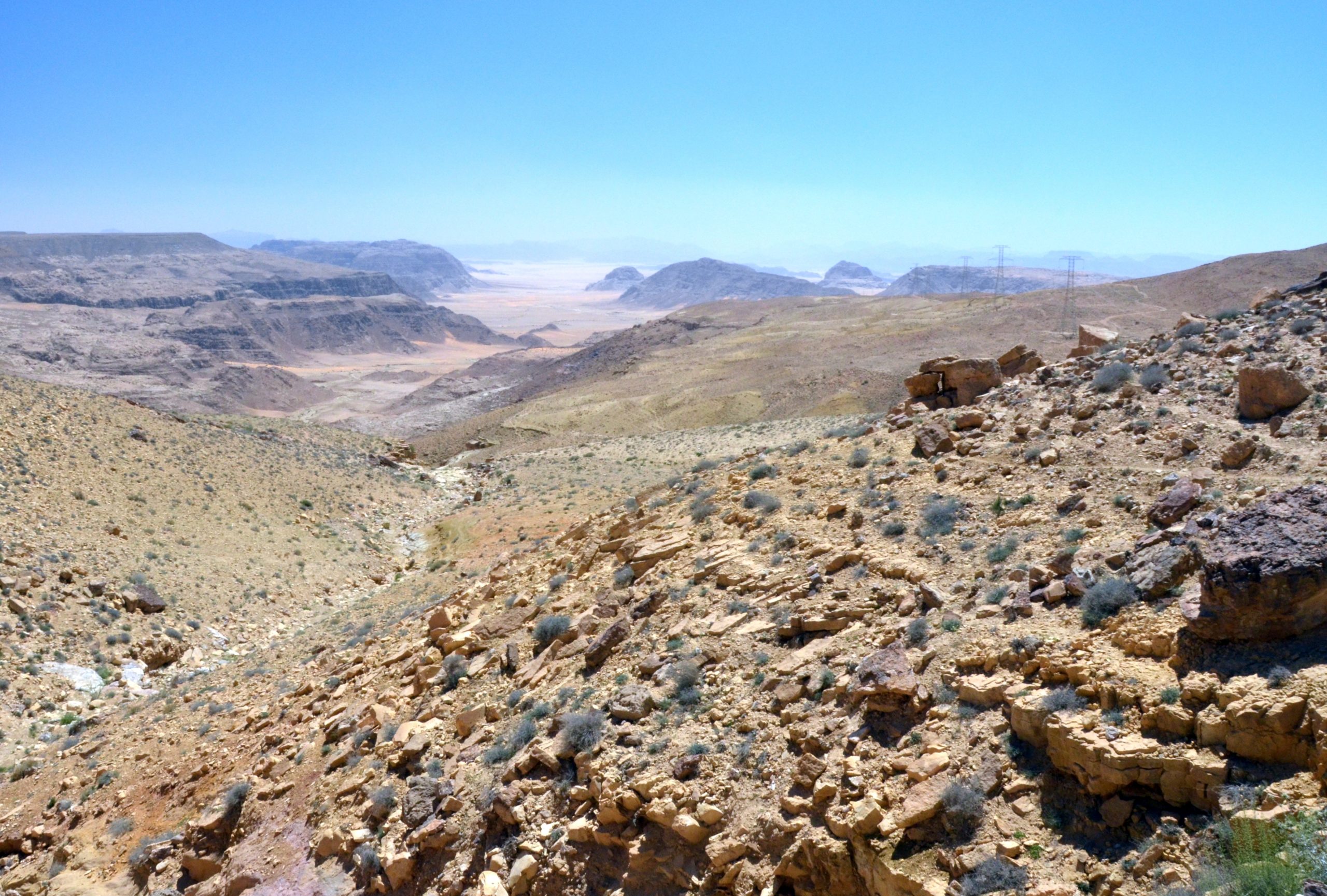
My first view of the Khatt Shebib was ten years ago. Standing on a hill-top near the southern Jordanian village of Waheida, I could see a dark, wall-like feature, ‘running’ across the landscape towards the horizon. For many years I have had an interest in linear features because they encourage and invite you to walk along them. They link places, form boundaries, control movement and may have acquired a multitude of functions over and above their original purpose. I wanted to explore this feature and try to work out its original use and age. The CBRL travel grant provided the opportunity to carry out an initial assessment and to gather information in the field for future project proposals.
The location for the first fieldwork was the stony desert area to the west of Ma’an. The initial task was to explore the Ras an Naqb escarpment, the steep boundary between the limestone uplands and the sandy desert and where the Khatt Shebib appears to begin and end. Using satellite and aerial images to locate the feature on the ground, I followed the line of stones down a shallow slope towards the south and the edge of the escarpment. Here, overlooking a rocky valley, was the southern terminal of the Khatt Shebib. Was this the start or the end of the line? I was unable to answer the question but was confident that its location was significant as it sat between two very different landscapes.
From here I moved to the area west and north of the village of Waheida. Here, the Khatt Shebib exhibits two different forms and, in some areas, is characterised by a series of short upright stones.
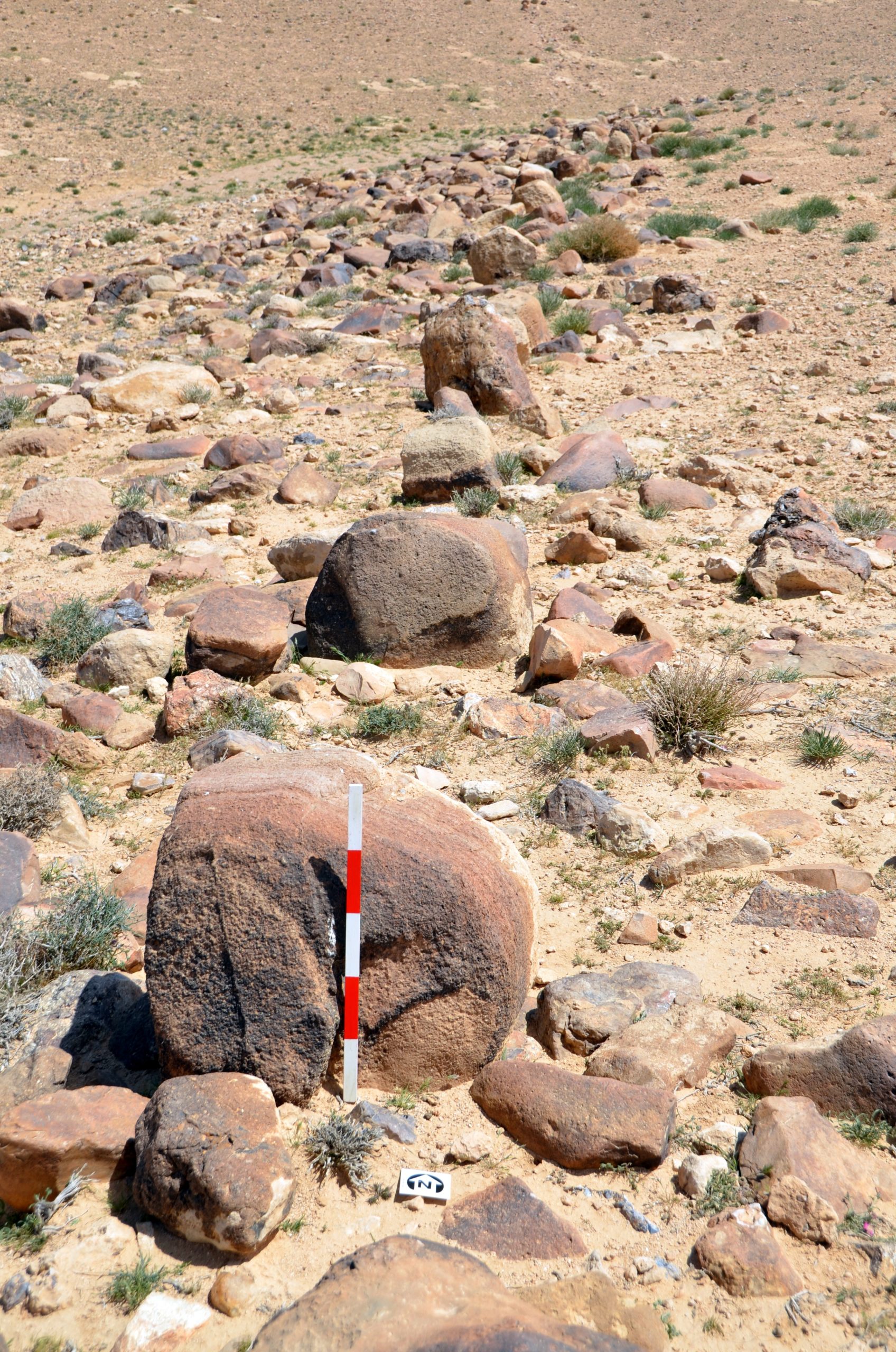
It also connects a series of stone-piles or cairns. This is an area needing future investigations to determine if the cairns were built against the feature or if the Khatt Shebib connected an existing line of cairns.

I next turned my attention the area to the south of the village of M’Reigha, 22 km southwest of Ma’an. Here, modern settlements and road building have had an impact on the Khatt Shebib. It is being (re)used as a boundary for new buildings and has become a focus for the dumping of rubbish. An example of why it is necessary to record and understand this feature in order to explain its significance to those who encounter it every day.
Aerial archaeology is a powerful tool in exploring linear features and The Aerial Archaeology in Jordan project (AAJ) has flown several sorties along the feature and have more than 270 images in their archive. These images are a valuable resource for tracing the line of the feature across the landscape and for exploring its relationship to the topography and other archaeological features. David Kennedy and Rebecca Banks have used these images to record and map the extent of the Khatt Shebib and have found that it extends to over 93 miles or 150 km. (93-Mile-Long Ancient Wall).
There is much work still to be done to try to understand this feature. The AAJ will continue to photograph and monitor the Khatt Shebib, and the possibility of making video recordings while flying the entire length is being explored. However, I believe that there is no substitute for walking the landscape to get an appreciation of the construction of the ‘wall’. Field-walking will form the critical task for my future work, and I plan to walk and record the entire 150 km, over two or three visits to the area.
I wish to acknowledge the assistance of the CBRL and EAMENA in making this initial study possible and to Dr Fawazi Abudanah for his advice and local knowledge.
A gallery of more photographs can be seen HERE
John B. Winterburn is a Landscape Archaeologist who works principally in southern Jordan. He was a researcher and landscape specialist for the Great Arab Revolt Project and completed his PhD in 2015, on the Conflict Landscapes of Southern Jordan. He is an Honorary Researcher at the School of Archaeology at Oxford University and contributes to the Endangered Archaeology in the Middle East and North Africa project ( EAMENA).
The views expressed by our authors on the CBRL blog are not necessarily endorsed by CBRL but are commended as contributing to public debate.

